Atlas of Iran
Iran |
||
|---|---|---|
 Iran with administrative divisions shown.
|
||
Location of Iran
|
||
Official Website: http://www.bahaisofiran.org/
Statistics
Population: 80,277,428
Bahá’í pop.: 300,000 [1]
History
First Local Assembly: 1899, Tihran
First National Assembly: 1928 (as Nat'l Spiritual Assembly of Persia); 1934 (representing entire country; disbanded 1983)
First National Convention: 1927
Regions of Iran
[edit]Iran can be divided into several overall geographical regions which are comprised of a total of 31 provinces.
-
 Geographical regions of Iran:Region 1Region 2Region 3Region 4Region 5
 -
 Region 1: Alborz, Golestan, Mazandaran, Qazvin, Qom, Semnan, and Tehran Provinces.
 -
 Region 2: Bushehr, Chaharmahal and Bakhtiari, Fars, Hormozgan, Isfahan, and Kohgiluyeh and Boyer-Ahmad Provinces.
 -
 Region 3: Ardabil, East Azerbaijan, Gilan, Kordestan, West Azerbaijan, and Zanjan Provinces.
 -
 Region 4: Hamadan, Ilam, Kermanshah, Khuzestan, Lorestan, and Markazi Provinces.
 -
 Region 5: Kerman, North Khorasan, Razavi Khorasan, Sistan and Baluchestan, South Khorasan, and Yazd Provinces.


Demography
[edit]Population
[edit]-
 Population density (2004).
 -
 Population density by counties (2021).

_-_Farsi.svg)
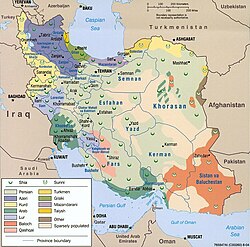
Language, ethnicity, and religion
[edit]-
 Linguistic and religious groups of Iran (2000s).
 -
 Ethnoreligious distribution (2004).


History
[edit]Background
[edit]Qajar Iran
[edit]Before the Bahá’í era
[edit]
Prior to the dawn of the Bahá’í era, Persia had been in flux. In the anarchy that followed the death of Nader Shah and the collapse of the Afsharid dynasty, rival army commanders fought for power, and the former empire broke apart. For a time the Zand dynasty, ruled from Shiraz by Karim Khan, controlled most of contemporary Iran, but his death in 1779 led to another civil war. From this conflict, Agha Mohammad Khan Qajar emerged victorious, becoming the undisputed ruler of Persia and founding the Qajar dynasty. He was succeeded by his nephew, Fath-Ali Shah Qajar, who would later call Mírzá Buzurg, a native of Núr in Mazandaran, into his service as a calligrapher and vizier.
Buzurg relocated to the Qajar capital, Tehran, in the early 1810s, at a time when the Russian Empire was attempting to retake control of the Caucasus; they would emerge victorious in 1813, notably leaving Georgia, parts of Armenia, and most of Azerbaijan in Russian hands. As Mírzá Buzurg settled into Tehran in relative peace, he became a prominent and successful member of the nobility, being granted the position of Governor of Burujird and Luristan by Qá'im-Maqám, the Grand Vizier of Persia. It was in Tehran in 1817 that a son was born to Buzurg and his wife Khadíjih Khánum: Mírzá Ḥusayn-‘Alí, to become known as Bahá’u’lláh.
Persia around the time of the events in Nabíl's Narrative: The Dawn-Breakers
-
 Detailed map published in the 1930s.
 -
 Simplified map showing locations of importance in Bahá’í history.


Pahlavi Iran
[edit]

Islamic Republic
[edit]
Media
[edit]
|
A collection of media related to Iran Events (Conferences • Conventions (Nat'l) • Establishments • Holy days • Publications • Seasonal schools (Summer • Winter)) |
Notes and references
[edit]|
General remarks
Notes References |
Entries available in the atlas
[edit]Table Of Contents
-
1.1 Regions of Iran
-
2.2 Demography
-
2.1.3 Population
-
2.2.4 Language, ethnicity, and religion
-
2.1.3 Population
-
3.5 History
-
3.1.6 Background
-
3.2.7 Qajar Iran
-
3.2.1.8 Before the Bahá’í era
-
3.2.1.8 Before the Bahá’í era
-
3.3.9 Pahlavi Iran
-
3.4.10 Islamic Republic
-
3.1.6 Background
-
4.11 Media
-
5.T-1 Notes and references
-
6.T-2 Entries available in the atlas